The Gympie region is home to some magnificent and historically significant bridges. Have you ever wondered how the bridges in the Gympie region got their names? Read on to find out more!
Shepherd Bridge (over Eel Creek on Rocks Road):
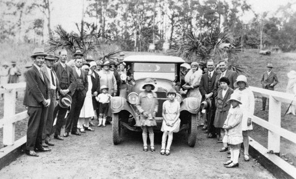
Opening of Eel Creek Bridge (Shepherds Bridge), circa 1920s. Source: Gympie Regional Libraries.
Click on the button below to see more photos of the opening of Shepherds Bridge.
This bridge is probably named after war veteran, local farmer and Widgee Shire Councillor C.T.O. Shepherd. Christopher Thompson Ousby Shepherd was born in 1877 in Warwick, Queensland. He married Lilian Alice Rickwood on 25 September 1909. In the Queensland Electoral Roll of 1913, Christopher and Lilian Shepherd were recorded at Redcliffe where Christopher’s occupation was “butcher”.
Christopher Shepherd enlisted at Brisbane on 15 July 1915. His appointment with the A.I.F. was terminated on 26 November 1918. In the Electoral Roll of 1919, Christopher and Lillian Shepherd were living at Wynnum. Christopher’s occupation was given as “soldier”.
On Friday 21 November 1924, the “Brisbane Courier” carried the story ”The resignation of Christopher T.O. Shepherd of his position as supervisor of the Beerburrum, Elimbah, Woombye and Lagoon Pocket Soldiers’ Settlements has been accepted as of the 30th of November 1924. In the Electoral Roll of 1925, Christopher Shepherd, supervisor, was recorded at Beerburrum. In the second print later that year, he and his wife were at Lagoon Pocket, Kilkivan, farming bananas.
On 8 March 1930, the “Brisbane Courier” carried news that Christopher Shepherd was one of three candidates who had nominated for two positions in No.3 Division in Widgee Shire Council. C.T.O. Shepherd was a Widgee Shire Councillor 1927-1936.
In the electoral rolls of 1936 and 1937, Christopher, his son Frederic and daughter-in-law Louisa were recorded at Lagoon Pocket farming bananas. By 1943, Christopher was a widower, still growing bananas at Lagoon Pocket. In the electoral roll of 1954, Christopher Shepherd was living with Hilda Grace Shepherd at 51 Lewis Street, Buranda. He died later that year on 25 October.
Sorensen Bridge (over Deep Creek on Cedar Pocket Road, over the dam):
Bill and Ethel Sorensen owned a farm near the bridge. Bill’s full name was Neils Henry Sorensen, but he was generally known as Bill.
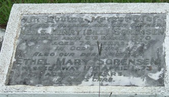
Gravestone of Neils Henry (Bill) and Ethel Mary Sorensen in Gympie Cemetery.
Spicers Bridge (over Kandanga Creek on Kandanga Amamoor Road):

Jack Spicer (Photograph source: Robin Murphy).
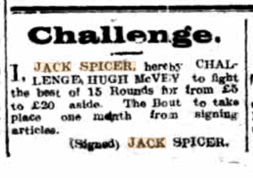
Advertisement in Gympie Times, 29th May 1917, p2
According to Jack Spicer’s granddaughter Robyn Murphy, the bridge is named after Jack Spicer who sapped (removed the bark) the logs for the bridge. Robyn said that he lived ‘just over the creek’ but his house burned down. His new house was in Amamoor. Jack was an athletic man and had a substantial boxing career. Robyn said she has never known the bridge to have a sign with Spicer’s name.
Tatnell Bridge (over Deep Creek on Cedar Pocket Road):
Tatnell Bridge is named after Joseph J. Tatnell, who was described a ‘farmer who had done excellent work as a councillor and resident’ (Courier Mail, 5th August 1936 p20). He died in 1946, aged 78. The Tatnells were among the district’s earliest pioneers with Joseph and Catherine having 10 children. After their son George’s birth, they moved to the top end of Cedar Pocket. Like many other local bridges, this bridge was first a crossing, already known as Tatnell’s Crossing in 1932. A new bridge was planned in 1932 and it was named Tatnell Bridge by 1936.
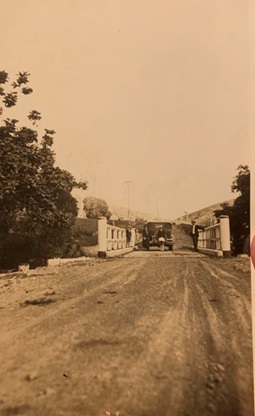
According to the family, this is a photograph of Grandad Tatnell’s car on Tatnell’s Bridge when it opened. The photograph is dated 27 October, 1933. (Photo source: Tatnell family photograph).
Thomas Powell Bridge (on the Bruce Highway, over Tandur Road at Tandur):
The bridge over Tandur Road on the Bruce Highway, south of Gympie, has been named Thomas Powell Bridge in recognition of the pioneering settler of Traveston Station.
Thomas Whitmore Bridge (over Pie Creek on Mooloo Road):
Thomas Whitmore was a gold seeker, and the first European to cross the Australian continent (Gympie Today, 22 Nov 2022, p1).

Route taken by Thomas Whitmore (Source: The Eye newsletter of Gympie and District Family History Society, Vol 5, No 1, April 1993).
The major bridges in Gympie Region have separate blogs posts with more information.
Click on the buttons below to read more about each of these bridges.
Did you enjoy reading about the history of the bridges in our region? Why not drop into the local history room at the Gympie Library to find out more!
Guest blog by volunteer Robyn
(Thank you to Robyn who researched and collated for this project).
References:
-Brisbane Courier. (1930). Widgee. Brisbane Courier. [Online]. 8 March 1930. Available at https://trove.nla.gov.au/newspaper/article/21514605?searchTerm=Christopher%20shepherd [Accessed 23 January 2025].
-Courier Mail. (1924). Supervisor Resigns. Courier Mail. [Online]. 21 November 1924. Available at https://trove.nla.gov.au/newspaper/article/22881438?searchTerm=Christopher%20shepherd [Accessed 23 January 2025].
-Courier Mail. (1936). Widgee Shire Council. Courier Mail. [Online]. 5 August 1936. Available at https://trove.nla.gov.au/newspaper/article/38502415?searchTerm=tatnell [Accessed 23 January 2025].
-Gympie Historical Society. (1993). Thomas Whitmore. The Eye Newsletter. Vol.5, No.1, April 1993, p.1.
-Gympie Today. (2022). Gympie man’s East to West journey. Gympie Today. [Online]. 22 November 2022. Available at https://gympietoday.com.au/news/2022/11/22/gympie-mans-east-to-west-journey/ [Accessed 23 January 2025].
