You may know some of our hill names such as Calton Hill and Caledonian Hill (off Fiveways Roundabout), but did you know most of the hills of Gympie have a name? How many do you know?
George Thomas compiled a publication named ‘How Gympie’s Streets were named’ in January 1964 and it was published by The Gympie Times as a booklet. He included some of the hills of Gympie*.
“There are in the area, seven prominent hill features, and many old timers likened them to the seven hills of Rome. Most of the higher features soon earned a name, but in later years, some of the higher points on these hills were also given a name. This particularly applies to the range that commences at a point near the Kidd Bridge, and then extends in horseshoe fashion to the end of Church Street on Calton Hill. On this range we find Surface Hill, Commissioners Hill, Horseshoe Bend, Palatine Hill, Tozers Hill, Caledonian Hill and Calton Hill.” — George Thomas
*Those marked GT (George Thomas/Gympie Times) descriptions have been sourced from the abovementioned booklet.
Here is an alphabetical listing of the HILLS of Gympie:
Topographical Map of Gympie and Environs
B. Dunstan, F. G. S, Government Geologist, 1910
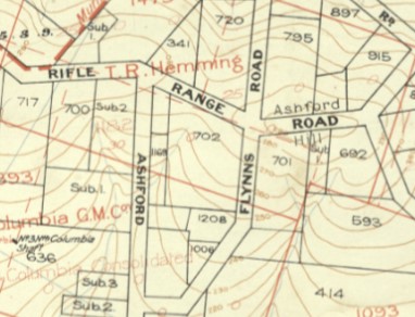
Ashfords Hill – This is an extension of Cootharaba Hill, and named after the late G. J. Ashford, previously referred to. (GT)
Brewery Hill – This is really a continuation of Kelihers Hill, and extends to the Mary River on the west. Named after Gympie’s first brewery, which operated on the high bank of the river for many years. (GT)
Topographical Map of Gympie and Environs
B. Dunstan, F. G. S, Government Geologist, 1910
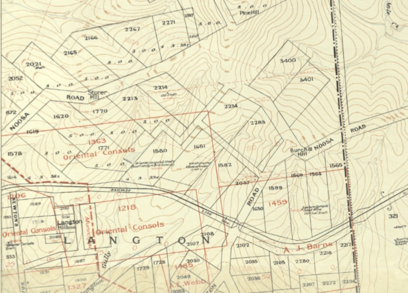
Burchill Hill – This is the rise near the junction of Hall and Noosa Rds, over near the Mothar Mountain Speedway grounds. It is also nearby Storer and Pine Hills. (BD, GRL)
Caledonian Hill – On the same feature as Calton Hill, and named after the Caledonian mine and reef. (GT)
Calton Hill – Named after hills of that name in the north of Scotland, not far from Edinburgh. (GT)
Cemetery Hill – This includes the high ground adjacent to the Gympie Cemetery, taking in the area between the Old Maryborough Road and Chatsworth Road (GT)
Commissioners Hill – This extends from the G.P.O (General Post Office – former Post Office, Duke Street) to the junction of Channon Street and Henry Street. (GT)
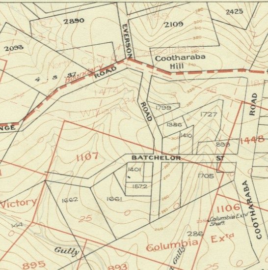
Cootharaba Hill – This extends from the N.C (North Coast) railway line to Cootharaba Road on the south and is referred to by me in previous notes. (GT)
Topographical Map of Gympie and Environs
B. Dunstan, F. G. S, Government Geologist, 1910
Dawn Hill – Off Dawn Road, at The Dawn are a cluster of hills named James, Maynard and Dawn Hill in the area of the New Dawn mine. (BD)
Dean’s Hill – This hill is at Widgee Crossing (North), just past the intersection of Widgee Crossing Rd and Rodney Road. (BD)
Fairview Hill – This is on the south-eastern corner of Gympie, and at the top end of Noosa Road. It has a high elevation and commands a fine view of Gympie and surrounding district – hence the name. 4GM relaying station is on this hill. (GT)
Ferguson Hill – This adjoins Pilchers Hill on the west, and named after the late Lt. Col. Ferguson, former Mayor of Gympie. This hill is the highest point in the city, being slightly over 400-ft. above sea level. The Council water tower is on the summit of this hill. (GT)
Geordie Hill – This is on the southern boundary of Gympie, and previously referred under heading of Geordie Road. 4GY transmitting station is sited on the top of this hill. (GT)
Hospital Hill – This was the site of the first public hospital to be built in Gympie. (GT)
Inglewood Hill- The first hill south of Deep Creek. Origin unknown. This Inglewood claim was taken up on December 10, 1867. (GT)
James Hill – Off Dawn Road, at The Dawn are a cluster of hills named James, Maynard and Dawn Hill in the area of the New Dawn prospect. (BD)
Jones Hill – This is the high feature on the western side of the Mary River, upon which is the reservoir supplying Gympie with water. Named after the late Richard Jones, who first found payable gold on the hill in a prospecting claim taken up by him in May, 1868. He was the grandfather of the late Walter Oswin, a very well known citizen of Gympie, who recently died in Brisbane, aged 88. (GT)
Kelihers Hill – The centre and highest part of this hill is at the junction of Duke Street and Pine Street, where there is a deep cutting in the former street. This was named for the father of the late Daniel and Jeremiah Keliher, who took up an area of land as a cow paddock in the early seventies (1870’s). Some of their grandchildren now have large grazing properties in the Gootchie district. (GT)
Langton Hill – Langton’s Road, Monkland.
Lucknow Hill – Is the hill which looks across from the Gympie Hospital across from Popes Road and the Gympie West General Store and Service Station (BD)
Maynard Hill – Off Dawn Road, at The Dawn are a cluster of hills named James, Maynard and Dawn Hill in the area of the New Dawn mine. Maynard’s Hill is named after Mr John Howard Maynard, sharedholder in the New Dawn Gold Mining Company. Maynard’s house and farm “Bunyarra”, Dawn Pocket was near Maynard’s Hill. (GRL, BD)
McAuliffe Hill – The hill of McAuliffe Rd, Monkland.
Mount Pleasant – This was named because it has a commanding view in all directions, and where there is always a pleasant breeze. (GT)
Normanby Hill – Normanby Bridge
O’Connell Hill – The area of the rise of the junction of Channon and O’Connell Streets, Gympie
Old Racecourse Hill – off Widgee Crossing Road (North) and across from Dean’s Hill. Gympie Creek runs behind this hill into the Mary River. (BD)
Palatine Hill – This is a spur running down from Horseshoe Bend (Lawrence Street) to Mary Street, on which the old Parish Hall (the original Church of England) and the Central State School now stand. It was named after Palatine Hill in Rome. (GT).
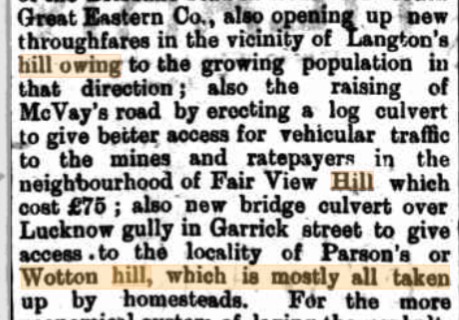
Parsons Hill – see Wotton Hill
Pilchers Hill – This was named after the late William Pilcher, who once owned the whole of the hill and had his home about 100 yards from the Council Reservoir. The late Mr. Pilcher conducted a grocery store in Channon Street, opposite the Masonic Temple, for many years. (GT)
Pine Hill – Pine Hill (and Storer Hill) are rises along Noosa Rd area. (BD, GRL)
Pope’s Hill – This was named after Edward Pope, previously referred to, and is situated between Louisa Street and Iron Street. (GT)
Pound Hill – This is on the south side of Deep Creek, and on the lower slope of Fairview Hill. It has a low elevation, and was the site of the first pound yard in Gympie. (GT)
Red Hill – This hill is in the centre of Gympie, and so named because the soil thereon, unlike that on other hills in Gympie, is red in colour and of good depth and quality. (GT)
Reid’s Hill – Named after Major David Elder Reid’s house “Glen Head” at Two Mile, off Chatsworth Road (house was named after his parent’s address in Scotland – Glenhead Road, Lenzie). Major Reid was an energetic businessman (assayer), politician and dairyman. This property was formerly of Mr W. M Davies and originally Mr Josiah and Charlotte Fowles named “Eagle Farm”. RB
Slaughter Yard Hill – This is a continuation of Cemetery Hill westwards. This was named for Elworthy and Mellor’s slaughter yards, which was situated where Strakers have their sawmill. (GT)
Storer Hill – Pine Hill (and Storer Hill) are rises along Noosa Rd area. (BD, GRL)
Surface Hill – This hill adjoins Commissioners Hill and takes in the land between the P.O (Post Office, former, Duke Street) and the river and upon which the Methodist Church (Surface Hill Church) now stands. It derived its name from the fact that the soil thereon contained some rich alluvial gold, and still does. I live on the western slope of the hill, and I possess some gold found by me on the surface of the road, following storm rains. I am reliably informed that in the very early days, many hundreds of cubic yards of the soil was removed and washed in the river. (GT)
Tozers Hill – Next to the Wide Bay Dairy Association’s factory, and named after Sir Horace Tozer, whose home was on the highest point of the hill. (GT)
Victoria Hill – Adjoins Inglewood Hill, and was the chief centre of business at the Monkland. Named after Queen Victoria. (GT)
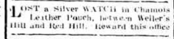
Weller’s Hill – Located near the Scottish Mine, Brisbane Road, Monkland. (GRL)
Wotton Hill – This is shown on recent maps as “Watton Hill”, but old residents of the area agree with me when I say it should be Wotton Hill, named for a person who resided thereon in the early days. (GT). Also referred to as Parsons Hill owing to resident John B. Parsons, in the late 1890’s (GRL).
Wotton is pronounced “with o as in Woman” (as per advertisement below by J. B. Parsons).

Sources:
BD – Queensland Geological Survey Publication No. 221A, Topographical Map of Gympie and Environs / B. Dunstan, F. G. S, Government Geologist, 1910
GRL – Gympie Regional Libraries research
GT – How Gympie’s streets were named / George Thomas, January 1964
RB – History of Avenue, formerly of Lot 31, Eagle Farm and Glenhead, Chatsworth Road, Two Mile / Robyn Bowman, 2016
